


Is it a mistake when everyone accepts the error?
In 1829, in an effort to bring certainty to town boundaries, the state legislature enacted boundary descriptions of all New York State’s towns. Milton’s east line was defined “by the east line of the fourteenth allotment of the Kayaderosseras patent and the same continued to the north line of the sixteenth allotment.” [Revised Statutes of the State of New York, Vol. III, Chapter 11, Title 4, page 52] Milton’s eastern boundary was a straight line, unchanged since Greenfield was cut out of it in 1793.
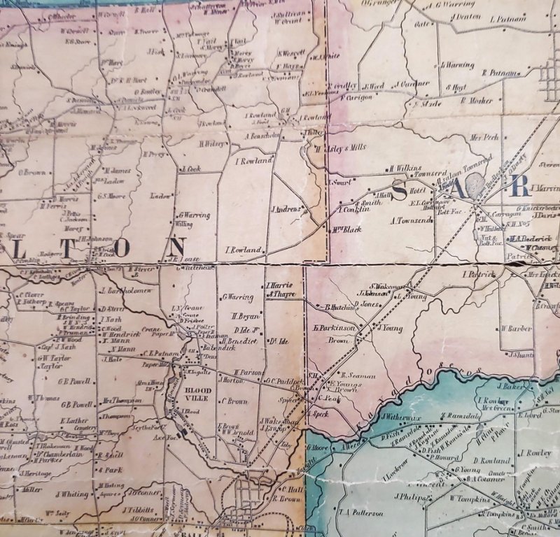
Until 1856, the few maps drawn of Saratoga County were relatively accurate, and all depicted Milton’s eastern boundary as a straight line, running due north and south. 1856 saw the production of an impressive wall map of the county from actual surveys.
This map paid attention to detail, laid out roads and lanes, located homes and businesses, and labeled each dwelling with the owner’s name. It was the most accurate map of the county up to that time.
However, Milton’s east line on the map was not straight. Rather, it followed the east line of the Fourteenth allotment only along the bounds of the allotment, when the line reached the boundary between the Fourteenth and the northerly Sixteenth Allotment, the boundary took a right angle to the east until it reached the southeast corner of Lot Nine of the Sixteenth Allotment and then proceeded north along the east bounds of Lot Nine until it met the southern bounds of the Town of Greenfield. According to the legislation of 1829, the easterly quarter of Lot Nine would be in the Town of Saratoga Springs.
With odd exceptions, such as the county map in Sylvester’s 1878 history of Saratoga County, that jog was depicted on succeeding maps down to the county highway map of 1941.
Town boundaries are subject to modification by the state legislature. Yet, a search of session laws from 1814 through 1856 revealed no such legislation. In 1849, most likely tiring of numerous local requests to change boundaries, the legislature allowed counties to modify town boundaries, so long as the change was filed with the Secretary of State. No change of Milton’s border is found in extent copies of the proceedings of the supervisors. Nor is there any evidence of a change in Milton’s boundaries in the office of Local Government Services, where such county-initiated changes are to be retained.
The offending 1856 map proclaimed that it was “from actual surveys by Samuel Geil.” Geil was not a local personage, but a resident of Bucks County, PA. Map making was his business. Saratoga wasn’t the only county to reap the benefit of Samuel Geil’s work. Niagara County’s map of 1852 was one of his earliest. Between 1852 and 1861, he produced at least 15 county maps. He was engaged between 1863 and 1865 to map the State of Michigan. Samuel and his nephew, John F. Geil were listed as surveyors in French’s New York Gazetteer of 1860. In 1856, maps of Saratoga, Greene, and Cattaraugus Counties were executed.
The amount of work needed to accurately lay out roads, properly locate houses, and place the correct name by each house is mind boggling. Obviously, he did not do the work himself and county-wide surveys were not executed. With such attention to detail in making the maps and the high degree of accuracy achieved, it is hard to envision that Geil and his crew would make such a major error.
An 1857 advertisement for an upcoming Eaton County, Michigan map was published in the Charlotte Michigan Republican provides a clue. The new map was to be prepared from “county records and actual surveys.” It was to contain “all public roads ...exact locations of villages. Post offices, places of Worship, Hotels, Stores, Farmhouses, Names of Property Owners,” etc. People who prepaid $5 would have their map delivered.
County records were a primary source for the map. An examination of deeds to properties located in the eastern half of Lot Nine of the Sixteenth Allotment of the Kayaderosseras Patent reveal an interesting pattern. With one, perhaps two exceptions, the deeds began boundary descriptions with the phrase, “All that certain piece of land situate in the town of Milton,” not, “situate in the towns of Milton and Saratoga Springs.”
When the original farm parcels of Lot Nine were sold off in the 1780s and early 90s, Lot Nine would have been divided between the Towns of Ballston and Saratoga. Those early deeds were silent about the town in which the land was located. Also, most of these parcels bordered today’s Rowland Street. Throughout the 19th century and before, that road was part of a main route between the Mohawk River at Scotia and the Hudson River at Corinth. Property owners along the eastern side of Rowland Street would exit their properties on Rowland and travel north or south. They were not oriented to Saratoga Springs and assumed their lands were in Milton. By the early 1800s, most deeds reflected that assumption.
A likely explanation for the error is that Geil’s researchers looked upon the deed descriptions as valid and did not double check with the laws of 1829. They, like the deeds they had read, treated all of Lot Nine as being in Milton, drew the map accordingly, and created a fallacy which was believed for over a century. The map had such power that taxes for land in Saratoga Springs were paid to Milton.
The creation of the City of Saratoga Springs in 1915 did not bring this issue to the fore. While the new city combined the Village and Town of Saratoga Springs, creating the “Inner and Outer Districts,” its western boundary was defined as Milton’s eastern boundary. The Town of Milton continued to collect taxes from owners of land in the jog. The newly minted city of Saratoga Springs did not complain.
Saratoga County’s hiring of professional planning staff in the 1960s resulted in questions over the century old practice, and in 1969, landowners in the jog found Saratoga Springs’ tax bills replacing Milton’s.
John Cromie is the former Ballston Spa Village Historian with a lifelong interest in local history. He has authored an architectural survey of Ballston Spa, and currently serves on the Board of Trustees of the Saratoga County History Center.